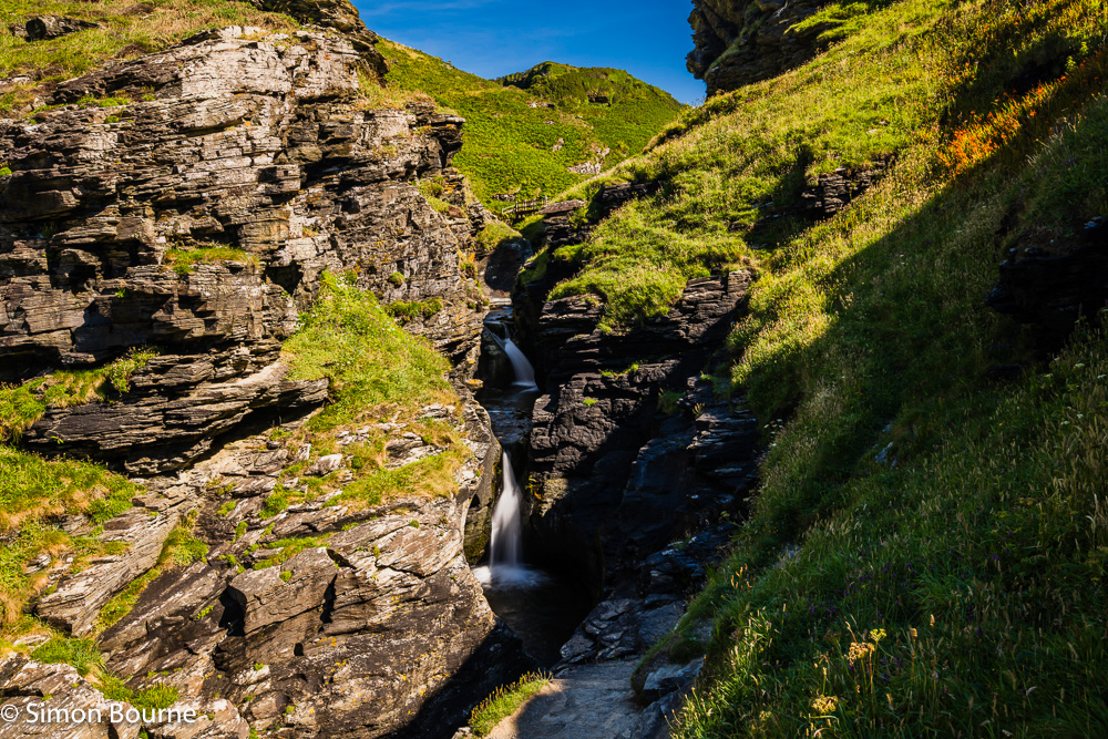
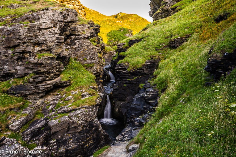
Jul 26 – Long Exposure at Rocky Valley Waterfall, Cornwall
I tried another long exposure down at these waterfalls a few days ago, but slightly earlier in the afternoon, when the sun would be shining more on them, but before it set behind the hills. It was at about 4.30pm that turned out to be the best balance of light.
This time around the overall scene was brighter at about EV 13, which would produce about a 1/60s exposure at f/11 and ISO 64. I therefore used a 5-stop ND filter (actually, a 2-stop and a 3-stop combined) to increase the time to about 1/2s. I took a range of photos through 1/8s, 1/4s, 1/2s, 1s, 2s and 4s, as sometimes you can get slightly better effects at other exposures. As it happens, this one at 0.6s was the best of the bunch – the shorter exposures were not quite milky enough, while the longer ones started to pick up some diffraction softness (as you edge closer to f/22) without much of a difference in the overall milkiness.
I used my wide-angle Z 14-30mm f/4 S lens this time, at 24mm. The best WB was at 5,750K, while I held the sky back by 0.6 stops, but lightened the higher set of falls (which were still in the shadows) by a further 0.5 stops.
Overall, it was a slightly different shot to my last ones in the early evening, but both would benefit from a bit more water crashing over the falls, but we won’t get that until the autumn now, when the light will be different again!
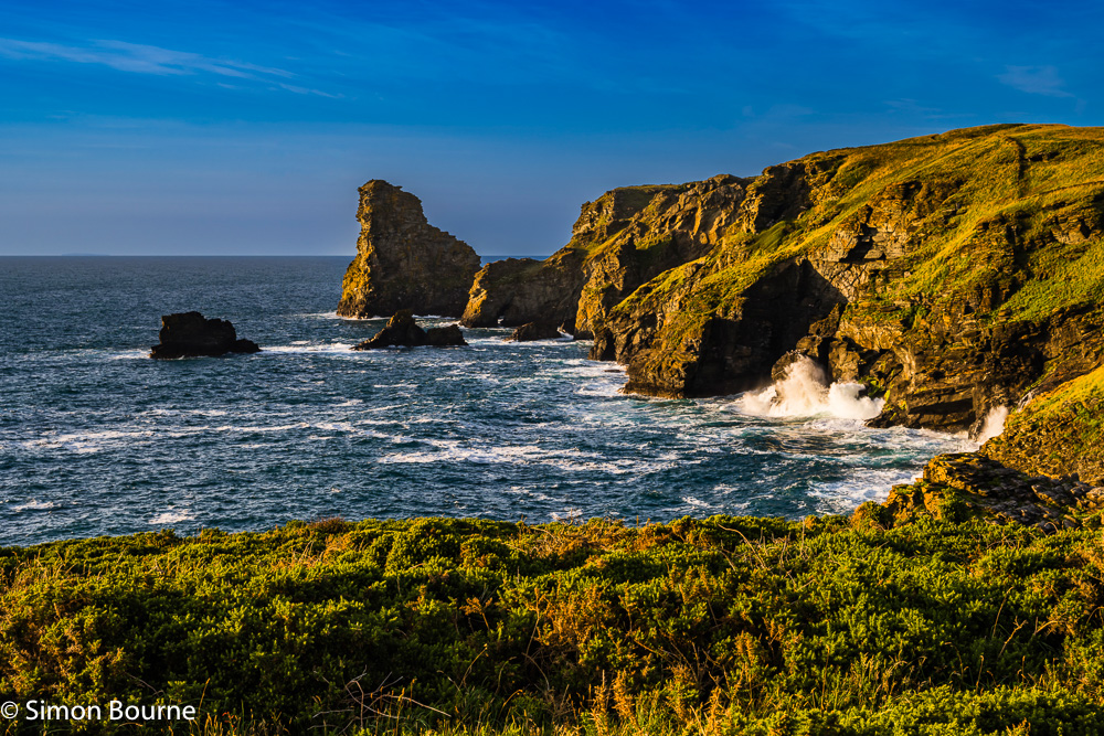
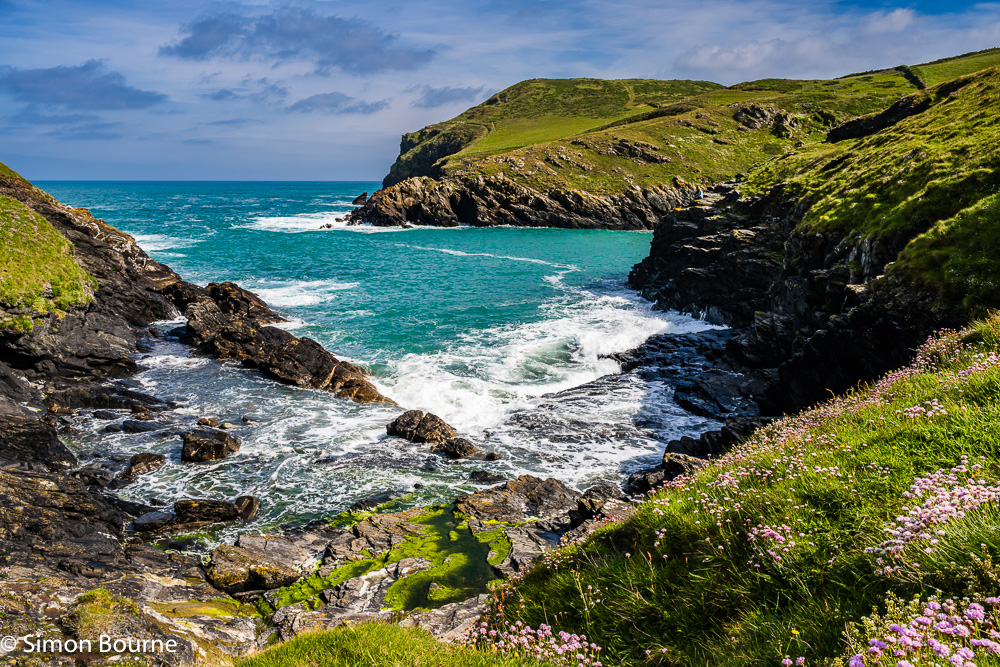
Jul 26 – Amazing Geological Features at Millook Haven, Cornwall
We went exploring around Millook last week, mainly to walk down the wooded valley to look at the dwarf oak trees, as it was close to high tide and the beach would be inaccessible. But, we arrived much later than expected as it had been raining all morning, and it was therefore low tide instead. So, we spent most of our time on the beach instead, in brilliant sunshine – typical Cornish weather change.
As it turned out the dwarf oaks are not particularly in the Millook Water Valley, but down near the cliffs at Dizzard Point, about 2.5km away. These are some of the oldest woodlands in the UK, dating back to 4-6,000 BC. Anyway, we missed them and they will have to wait for another time!
However, the beach was spectacular – we didn’t know beforehand that Millook Haven is one of the top ten geological sites in the country. We have been to nearby Crackington Haven lots of times and that has amazing rock formations, but Millook Haven is even more dramatic. The sedimentary layers of sandstones and shales were laid down deep underwater over 320m years ago as the Crackington Formation, and were pushed up during a continental collision (the Variscan orogeny) about 290m year ago.
The resulting deformation of the rocks has formed these wonderful recumbent chevron folds. The first shot of one of the cliff faces was taken at 47mm, f/11, 1/100s and ISO 80, while the second close-up detail used 60mm, f/11, 1/100s and ISO 100. Having done geology in my first year of a Civil Engineering degree, over fifty years ago, I do like a good rock formation!


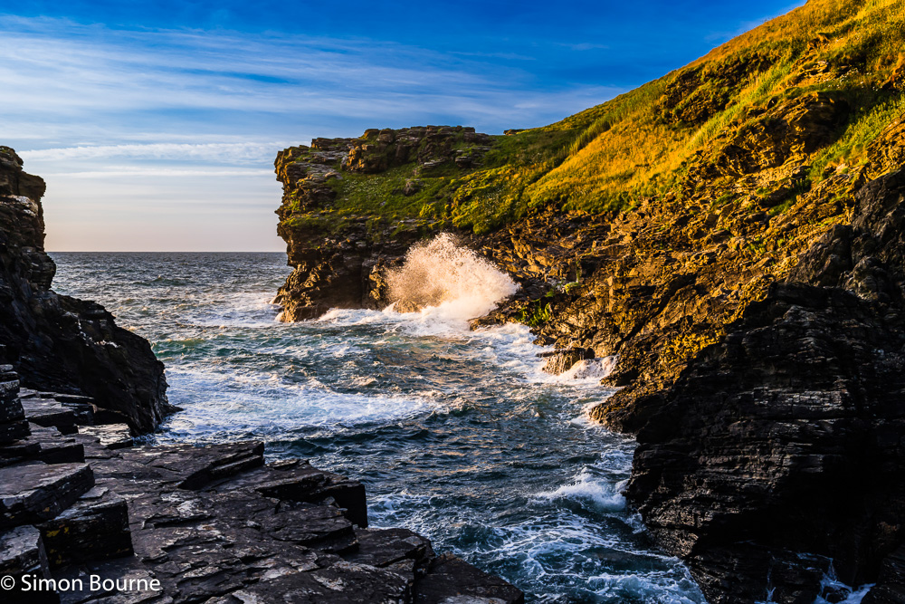
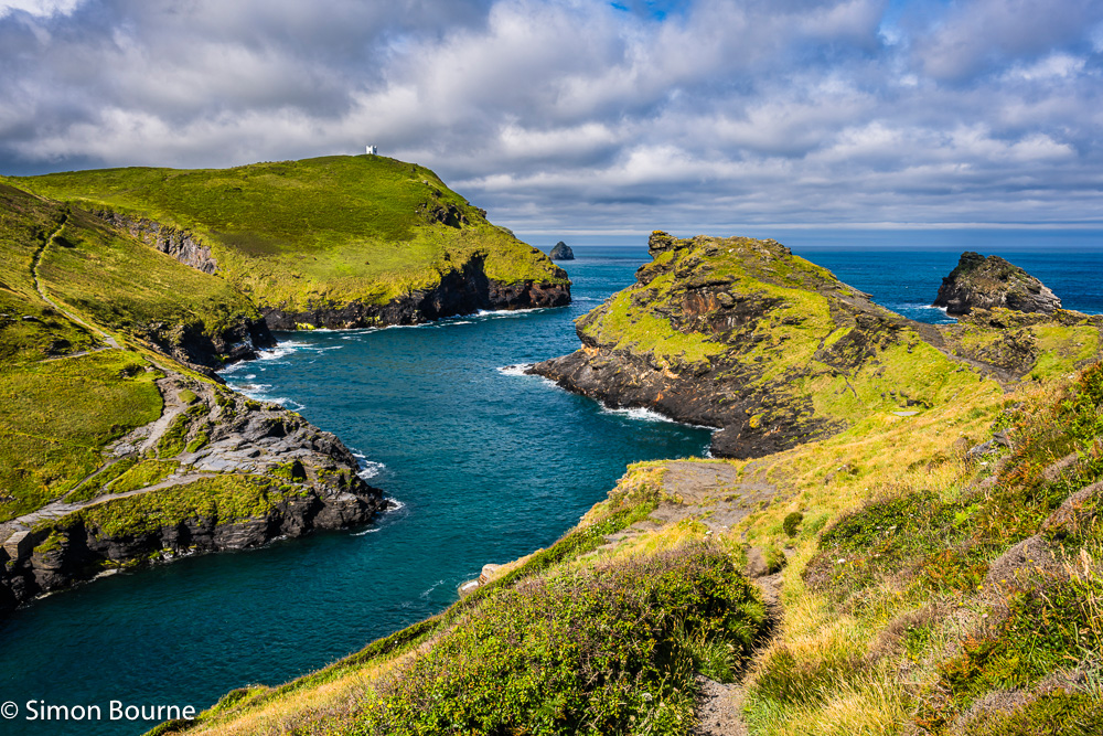
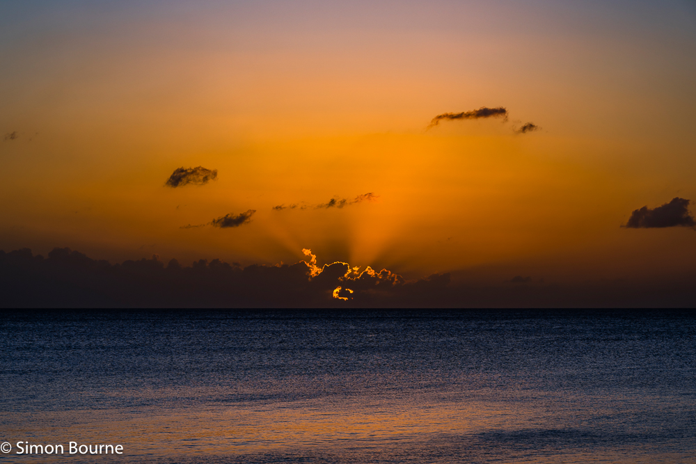
Jul 26 – Sunset down Rocky Valley, between Tintagel & Boscastle
Rocky Valley, which is halfway between Tintagel and Boscastle, is another location that should get the setting sun shining down the valley at this time of year, as it faces North-West. So, I went down there a few days ago at about an hour and a half before sunset, ie at 8pm.
The sun was actually too low to shine right up the valley to the set of waterfalls, but it did provide a lovely yellow/orange glow on the hills behind. I was also trying to get some long exposure shots of the falls. Once the shadows come over the water, the light levels drop to around EV 11, and therefore with an f/8 aperture (for good DoF) and a minimum shutter speed of 1/125s (to freeze the water), you need ISO 400, which is OK. I would actually prefer though to use f/11 and 1/250s, but that then needs ISO 1,600, which is too high for my liking. Hence, it is better to switch to long exposures, using f/11 and ISO 64, for example, though these settings only get you to 1/10s. You can then add ND or polarising filters to reduce the light, or reduce the aperture and lower the ISO a bit more. I went here with 24mm, f/18 (to avoid getting too much diffraction at f/20-22) and ISO 32 (this is 1-stop below my native ISO 64), which allowed me to use a 1/2s exposure, which gave a good milky consistency to the water.
About half an hour later, at 8.30pm, I walked to the end of the valley, where it meets the sea, and up on to the clifftops. It was high tide with surprisingly large surf, given that it was not really windy. The light on the cliffs had definitely shifted to orange now, which made for a lovely evening scene. This second image was taken at 50mm, f/9, 1/160s and ISO 125.
Finally, at nearly 9pm, about half an hour before sunset, I went back down to the end of the valley. Here, the high tide was very choppy with Atlantic breakers crashing on the rocks, all lit on one side by a wonderful orange glow. With it now being another stop darker, I shot this third photo at 34mm, f/8, 1/200s and ISO 250.
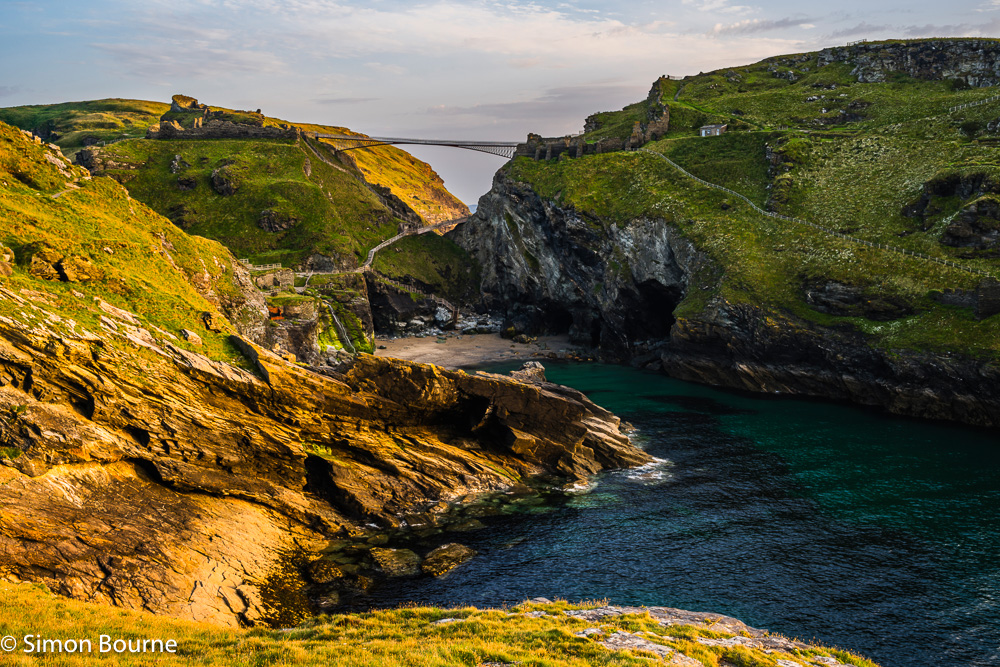
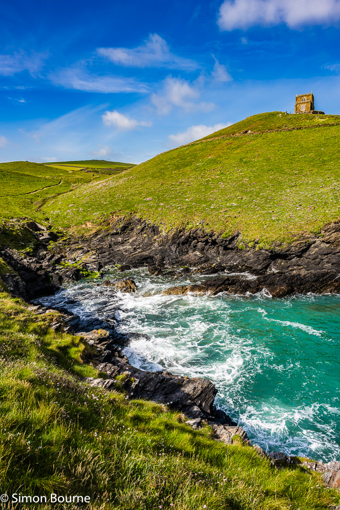
Jun 26 – Sunset near the Solstice, Tintagel Haven, Cornwall
As noted in my last blog, the sun only sets far enough north, in the North-West, around the time of the summer solstice. My Photographer’s Ephemeris app had shown that the sunset would not quite shine directly on the waterfall at Tintagel Haven, but it would probably light up enough of the surrounding cliff face to make for an interesting shot.
It was very hazy in the end at dusk, but about an hour before the sunset, there was enough of a break in the low clouds to allow the sun to shine through with sufficient power to generate a lovely orange glow, but only for a few minutes.
Obviously, at this time of year the flow in the River Trerammet is quite low, making the waterfall less spectacular, but when the river is in spate over the winter, the orange light would not be there! Anyway, it was a very picturesque image of the whole haven in the end, with the castle ruins, the two footbridges and the caves, including Merlin’s Cave on the left, together with the beach at a very calm, low tide.
This photo was taken at 37mm, f/11, ISO 64 and 1/8s using a tripod. The most accurate WB was at 7,000K and I held the sky back by 0.8 stops in Lightroom to avoid it being too bright compared to the rest of the scene. There were quite a lot of people on the beach too, whom I carefully removed in Photoshop – cannot have them spoiling my nice and clean landscape!
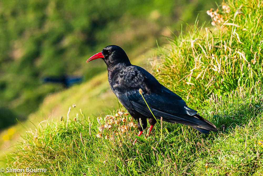
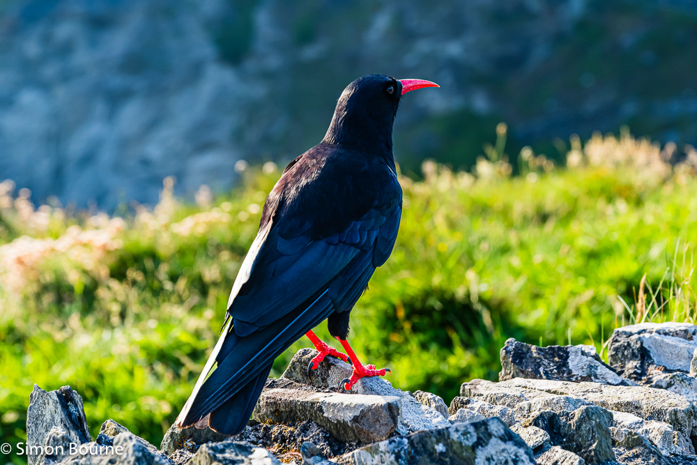
Jun 26 – Rare Sighting of a Chough, Tintagel, Cornwall
I was walking last night up to Tintagel Haven to capture the waterfall in the orange glow of the setting sun – it’s only around the summer solstice that the sun sets far enough north to cast any light on the falls. As it turned out, the clear blue skies became very hazy quite quickly, and the shot never really worked – the water levels are low at this time of year too, of course.
Anyway, just by the castle ruins at about 8pm, I came across a Chough (Pyrrhocorax pyrrhocorax). Despite being the bird of Cornwall, they are very rare, especially this far north and east. They disappeared from Cornwall in the 1970s but have re-established a small community since 2000 around The Lizard. I had seen an article in The Guardian last month about them being spotted around Tintagel Island and Castle. There are only two pairs though and so they would still be extremely rare. I thought at first that it was a Jackdaw or Crow, but the red legs/feet and beak were a quick giveaway.
I had my Z 14-30mm f/4 S on the Z 7II camera (anticipating my landscape and tripod shots) but did also have the Z 24-120mm f/4 S in my backpack. Staying about 4-5m away, I quietly opened my bag, swopped lenses and got the camera in to wildlife mode. This first shot was of it resting after feeding on the grassy banks of the clifftops, taken at 120mm, f/5.6, 1/500s and ISO 360.
I took about 30 photos to ensure some good shots and then crept closer. It seemed totally unconcerned by me as it hopped across to the wall overlooking the island. I got to within about 2m, taking another 30 images, before it flew away. This second photo was at 75mm, f/5.6, 1/500s and ISO 640.
With a black bird against a very light background, the exposure was tricky, and so I went mid-range and then darkened the background by 0.4 stops in Lightroom with a mask, and lightened the bird itself by 0.3 stops with a subject mask.
There is a strong connection to the legend of King Arthur too, who having been conceived at Tintagel, has his spirit living on in the shape of a Chough – the red feet and beak representing his bloody end!
Jun 26 – Summer Surf around Boscastle, Cornwall
Boscastle Harbour was looking great last week, on a stormy summer’s morning between the rain showers. It had been wet for two weeks here, but a respite appeared, though it was still very windy. It was high tide and the mixture of the white breaking surf and aquamarine waters was gorgeous. The white Lookout Station on the Willapark headland provided the focal point while we climbed Penally Hill on the other side of the harbour, which is always much quieter than the more popular left side.
You can see the Short Island rock out at sea on the left, which is around by Bossiney Haven bay, and the Meachard rock that sits outside the harbour, on the right. This first image was taken at 27mm on my Z 24-120mm f/4 S lens, using f/11, 1/160s and ISO 100. I darkened the sky using a mask in Lightroom by 0.6 stops and then opted for a WB of 6,000K.
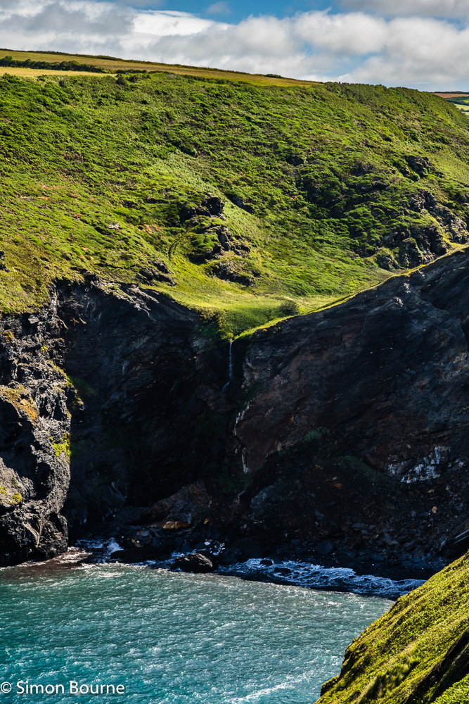
We then walked north along the South West Coast Path to Pentargon Falls, where a small river drops 35m from a hanging valley on to the beach below. The hanging valley forms as the Atlantic waves have eroded the cliffs much faster than the river has cut through the valley above. The summer flow in the river was quite low, despite all our rain recently, making it difficult to really see from a distance, but this closer view shows it a bit more clearly – it’s not Milford Sound though! Here, I zoomed in with 93mm, using f/11, 1/160s and ISO 160 to get better coverage of the shadows. I held the sky back by 1.0 stops (as I was more facing the sun) and lightened the cliff face by a further 0.3 stops with a brush mask. The slightly darker setting also made me push the WB up to 6,250K. I’ll go back there in the autumn when the river is in spate and more dramatic – it will be better in the late afternoon too with a bit of setting sunlight. The waterfall faces almost exactly West and so around the autumn or spring equinox should be perfect
May 26 – Spring Swell around Port Quin, Cornwall
We’d been for a swim at Port Quin nearly two years ago, but had never been back to explore it further. It’s a lovely little harbour, very quiet and off the beaten track, especially compared to nearby Port Isaac, which can be packed with visitors.
We walked up the left side of the harbour towards Doyden Point, upon which sits Doyden Castle – a Grade II listed folly built in 1830, but now used as a one-room holiday let through the National Trust. The tide was high and there was quite a breeze, generating good swell and crashing surf on the lower rocks. This first photo was taken at 24mm on my Z 24-120mm f/4 S lens, using f/10, 1/160s and ISO 100 – the bright aquamarine waters looked stunning in the early morning sun.
The second shot was looking across the harbour entrance towards Kellan Head. The Cornish Sea Thrift (Armeria maritima) is very prevalent on all the cliff tops currently, with vast swathes of small, bright pink flowers – they are particularly prominent in May and June. They add a wonderful bit of texture and foreground to the dramatic seascapes. This view was taken at 28mm, f/11, 1/160s and ISO 100.
Both images used a WB of 6,000K and I held the sky back by 0.5 stops in Lightroom. Unusually for Cornwall, there were lots of airplane contrails in the sky, which rather spoilt the natural feeling of the images, in my view. So, I carefully removed them all in Photoshop!
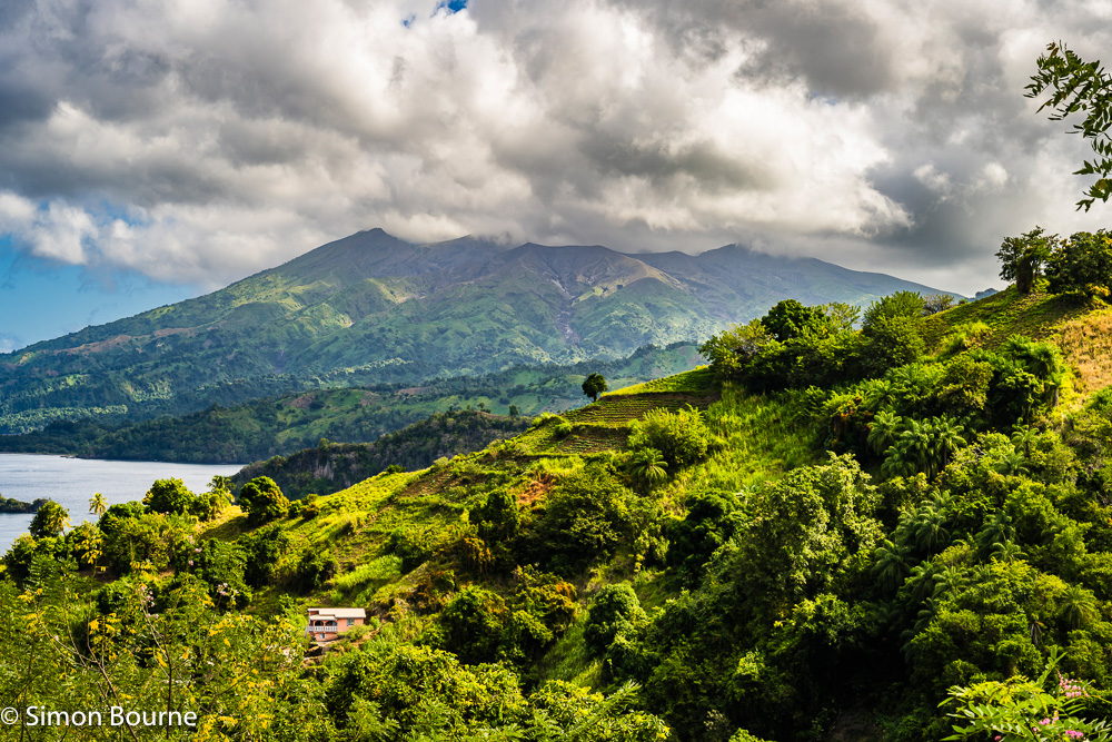
Apr 26 – Volcano and Falls on the Leeward Side, St Vincent
Whereas the Leeward Side (the Caribbean Side) of Barbados is very flat (and rather filled with hotels), the Leeward Side of St Vincent is very steep and rugged – a dramatic feature of its volcanic nature. We drove all the way up the Leeward Highway to pretty much where the road simply stops, before the slopes of the volcano, La Soufriere, make it impossible to travel any further north – you can actually only reach the north point of the island on the Windward Highway.
From Troumaca, I took this early morning image of the volcano, with Chateaubelair Bay on the left. This is the last village on the Western side before the road runs out. La Soufriere is an active stratovolcano rising to 1,235m and last erupting in only 2021. The location that we were stood was covered in about a metre of volcanic ash only 5 years ago! But the area recovers quickly and the vegetation grows enormously well, with the soil being so fertile. It was taken at 54mm, f/11, 1/125s and ISO 100 on my Z 24-120mm f/4 S lens.
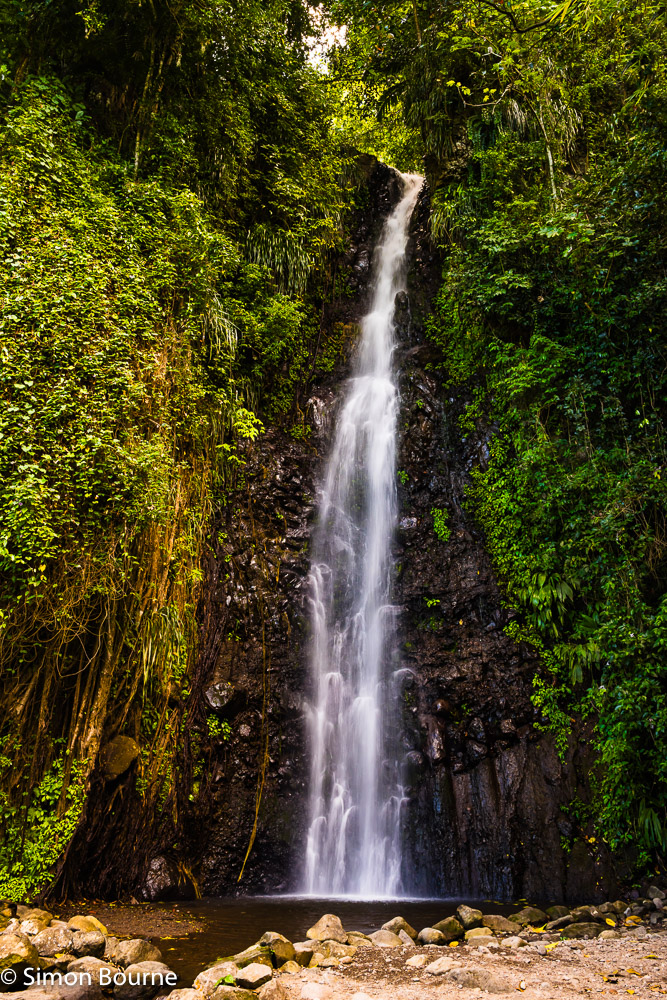
Just as the road ends, you can turn off to visit Dark View Falls. This is a 25m high, though small volume, waterfall on a tributary of the Richmond River, which flows down from Richmond Peak at 1,074m. I didn’t have my tripod with me, but was able to take this slow-ish, hand-held exposure at 1/20s using the Z 7II’s excellent in-body stabilisation with VR, though it was also taken at a fairly wide angle of 28mm, which also helps. Otherwise, the photo used f/11 and ISO 200, as the overall light levels were down at about EV 9, ie 6 stops below a sunny day. I did take others at 1/125s with f/5.6 and ISO 400, but the DoF was not quite enough for my liking. The slower exposures for waterfalls are often much more appealing with their air of milkiness.
Only realised today though that there was another set of similar height falls just a few minutes climb to the top of these lower falls, which we completely missed!
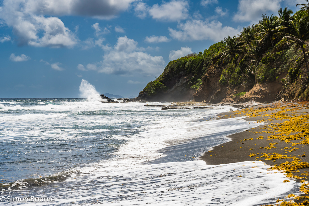
Apr 26 – Atlantic Ocean Waves and Surf at Biabou, St Vincent
As with the East Coast of Barbados, the East Coast of St Vincent, ie the Windward Side, is much quieter and dramatic too, with its Atlantic Ocean winds and rolling surf. This image is on one of the various beaches around the village of Biabou, which is just north of the main airport.
Here, the waves were crashing against the rocks as they come in to a classic volcanic beach with its black sand, all beautifully framed by the palm trees growing out of the cliffs. In the distance, you can see the two small Grenadine islands of Battowia and Baliceaux, both of which are uninhabited – Battowia is a bird and wildlife sanctuary, while Baliceaux is a sacred heritage site.
This image was taken at 68mm on my Z 24-120mm f/4 S, using f/11, 1/250s and ISO 64 – the WB was 6,000K and I held the sky back by 0.6 stops.
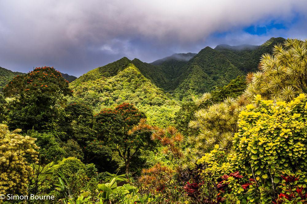
Apr 26 – Lush, Green & Floriferous Tropical Gardens, St Vincent
In the middle of St Vincent, at an elevation of around 450m, lies the wonderful Montreal Gardens, a real gem lying within the tropical forest at the top of the Mesopotamia Valley, which is famed for being the food basket of the island, due to its extremely fertile volcanic soil within the sheltered, wet valley. The active volcano in the north of the island, La Soufriere, which we visited a few days later, is the source of this fertility, while currently standing up at 1,235m.
It was a stormy day, with dramatic clouds and sunbursts, though not actually raining while we were there. This first photo is of the borrowed landscape to the 7.5 acre gardens, showing the wooded foothills of the Grand Bonhomme mountain, which rises to 973m. Besides the wide variety of palm trees in the gardens, the most prominent trees are the African Tulip (Spathodea campanulata) with their spectacular red/orange flowers. This image was taken at 37mm on my Z 24-120mm f/4 S using f/11, 1/160s and ISO 160.
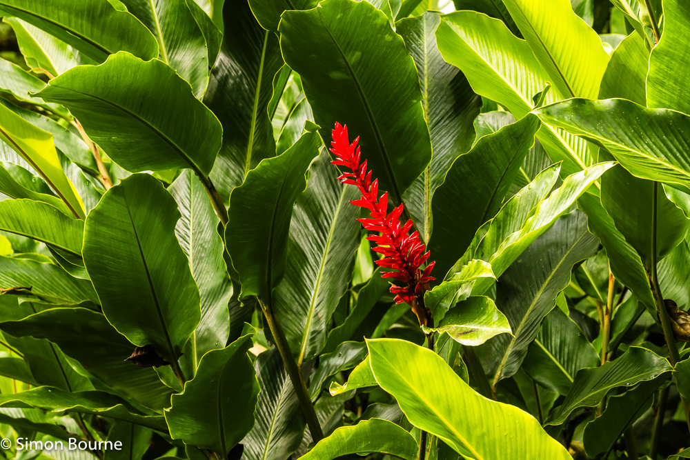
Common throughout the gardens were the Red Ginger (Alpinia purpurata) plants with their wonderful, bright red bracts. This closer image was taken using 88mm, f/9, 1/160s and ISO 250.
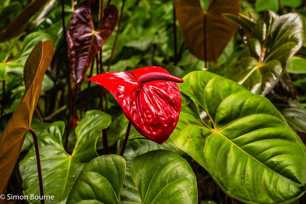
In a similar vein, there were plenty of glistening red bracts of the Anthurium andraeanum planted on the forest floor, acting as ground cover. This next close-up was captured with a 64mm focal length at f/8, 1/125s and ISO 250. The red here is also a bract, with the leaf-like structure being the spathe while the central flower-like stem is the spadix.
The most accurate WB for all the images was at 6,000K – you might expect it to be a higher temperature at a cloudy to shady figure of 6,500-7,500K, but the altitude or latitude seems to make some difference to the norms.
Apr 26 – Sunsets and Wildlife on Young Island, St Vincent
After Barbados, we flew a short hop to St Vincent and the Grenadines, which is a much more spectacular set of islands, being volcanic of course. It peaks at 1,235m and the whole island is so much more mountainous (and interesting for us) than the rather flat Barbados. It’s also quite a bit quieter, which is nice!
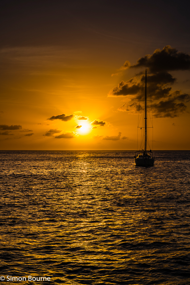
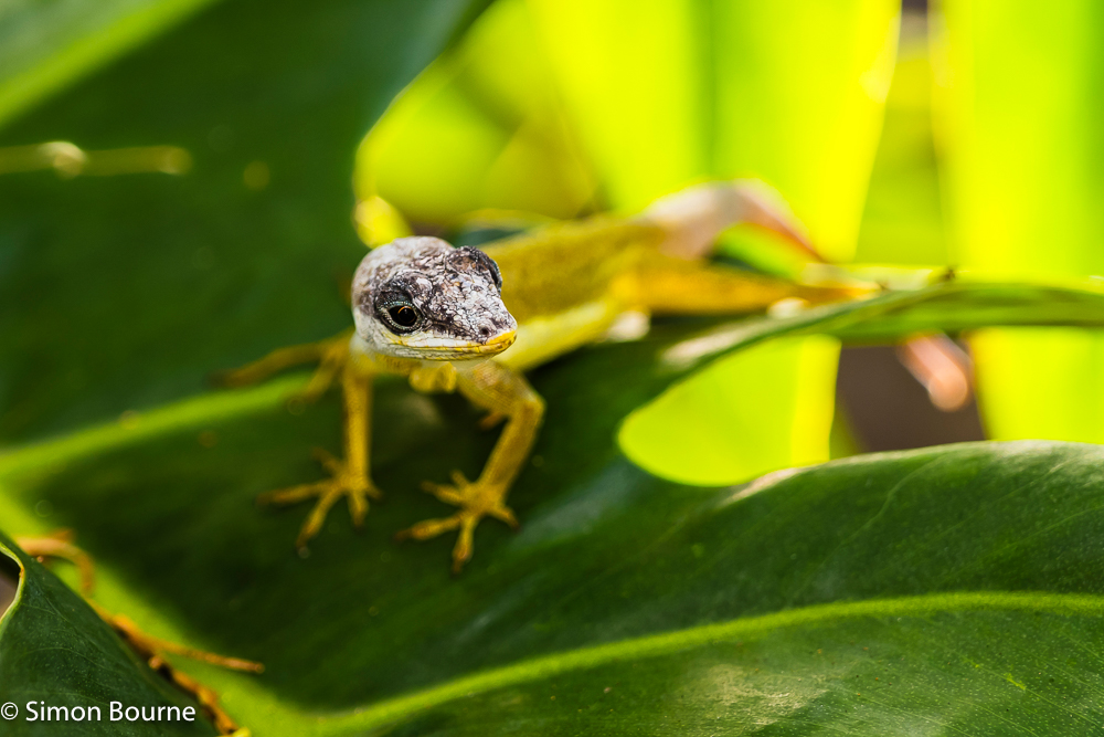
We actually stayed at a lovely hotel on the private Young Island, which is the first of the Grenadine islands, as they stretch southwards from St Vincent itself. This first image was 8 minutes before the sunset, with the last of the reflections off the Caribbean Sea, some crepuscular rays from the sun and clouds, and a moored yacht to add some interest. I used my full-frame mirrorless camera, the Nikon Z 7II, with the very versatile Z 24-120mm f/4 S lens, using it at 54mm, f/13, 1/250s and ISO 64.
Besides the hotel, there were no other properties on the island, making it very peaceful if you ventured away from the beach, up on to the rocky middle and outer edges of the island. There was not a huge amount of wildlife, but I captured this lizard on the vegetation – it’s actually a Tropical House Gecko (Hemidactylus mabouia), which is not a natural here, having been introduced inadvertently by humans! Here I used the same camera/lens combination at 120mm but with f/4, 1/100s and ISO 100, as it was very shady. The DoF is very small, as I was quite close too, making only about 20mm in focus. I had to be careful therefore to get both its eye and nose sharp. I did have to crop quite hard as well, taking it down from 45MP to only 6MP with a 3,000 by 2,000 pixel size. This is the smallest size that I can sell on Alamy.
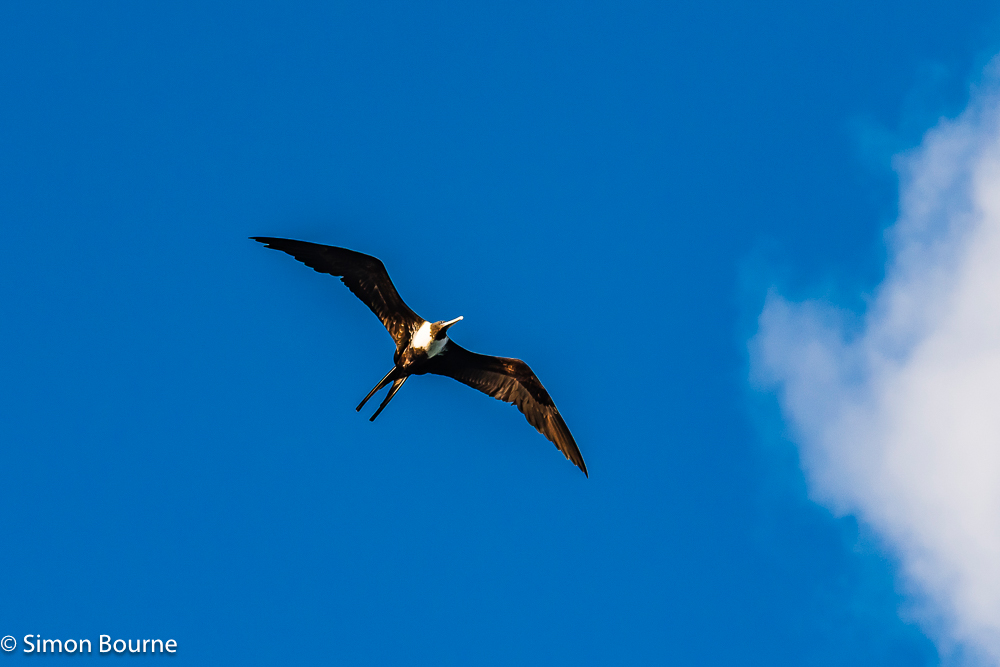
At the end of every day, there were lots of Magnificent Frigatebirds (Fregata magnificens) soaring in the warm evening air currents over the island. They seemed to be all the larger females that are defined by their white breast feathers. They have a wingspan of 2.0-2.5m and have the largest ratio of wingspan to weight of any bird, looking very similar to an albatross, though with their very distinctive forked tails. They never land on the water, catching fish in flight or by stealing fish from other seabirds, known as kleptoparasitic behaviour. Here, I used my D500 cropped sensor DSLR with the 70-200mm f/4 lens at 200mm with f/5.6, 1/2000s and ISO 250. I didn’t have my 200-500mm f/5.6 lens with me and so, again, I needed to crop the images hard from the base 21MP to 6MP to get a decent shot of the soaring bird in flight, lit by the setting sunlight.
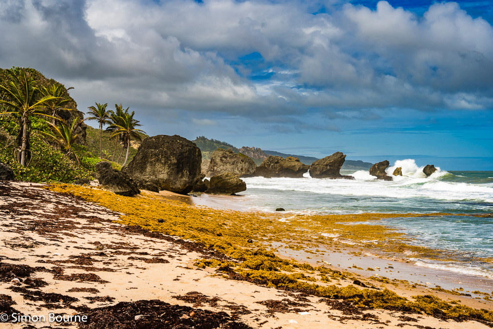
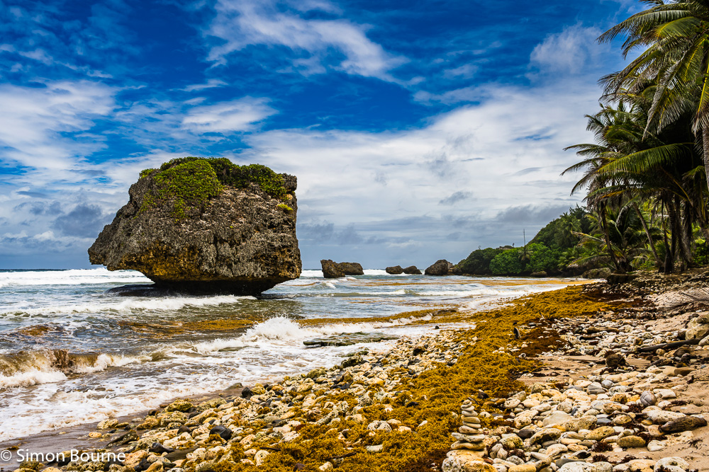
Mar 26 – Rolling Surf and Beach Rocks, Bathsheba, Barbados
As noted in my last blog, the East Coast of Barbados, ie the Windward Side, is much more dramatic with its Atlantic Ocean winds and rolling surf. These two shots are taken in the quiet fishing village of Bathsheba, which is famous for its large coral limestone rock formations on the beach. They look spectacular with waves crashing over them.
Unlike the other nearby islands in the Lesser Antilles or Windward Islands, Barbados is not volcanic but a karstic limestone island that has been pushed to the surface as the Atlantic tectonic plate pushed under the Caribbean plate. The younger (<1m years) limestone is up to 100m thick above a base layer of softer, and much older (~50m years), sedimentary deposits, known as the Scotland Group. At Bathsheba, the softer foundations of the older group in the cliffs has toppled lots of younger limestone boulders towards the sea. With further erosion for the Atlantic, these mushroom-shaped boulders form, also known as olistoliths.
The first photo is a wider view of the surf breaking on these boulders, but actually taken at 52mm on my Z 24-120mm f/4 S using f/11, 1/250s and ISO 100. The second picture is a closer view of one of the massive rocks, but actually taken at a wider angle of 31mm, using the same settings otherwise. Besides my usual Lightroom settings, both used a WB of 6,250K and I held the sky back with a mask by 0.6 stops.
On to St Vincent and the Grenadines next!
Mar 26 – Lush, Green and Floriferous Tropical Gardens, Barbados
The West Coast (the Leeward Side) of Barbados is pretty flat and busy, with lots of hotels, but not actually any large sandy beaches, whereas the East Coast (the Windward Side) is much more dramatic and sparser, with rolling Atlantic waves and surf. In the middle, though not too high up (it only peaks at 336m), it is very lush and green.
We visited three tropical gardens here at Welchman Hall Gully, the Flower Forest and Hunte’s Gardens. At Welchman Hall Gully, which is a naturalistic walk through a long, collapsed limestone cave, it was raining heavily and so very difficult to get any decent photos. By the time we got to the Flower Forest though, it was just brightening up, and then it was lovely and sunny by the time we walked around the wonderful Hunte’s Gardens. They are all quite close to each other, about halfway across the island.
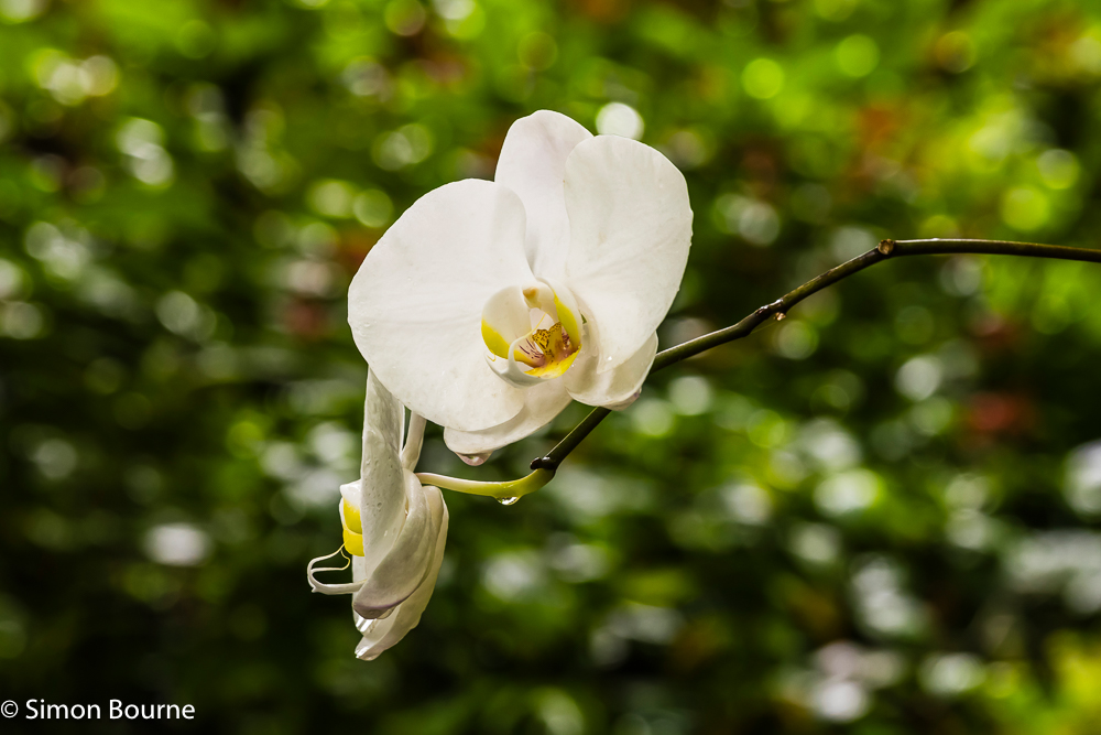
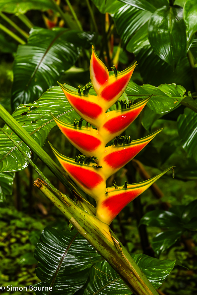
These first two close-ups were at the Flower Forest Gardens, which cover over 50 acres in the tree tops. The white Orchid (Phalaenopsis) was taken at 100mm on my Z 24-120mm f/4 S using f/8, 1/100s and ISO 400 due to the shady conditions, while the fantastic red and yellow Lobster Claw Heliconia (Heliconia bihai) used 105mm, f/9, 1/100s and ISO 400. You can see how much they are both covered in water drops from the rain.
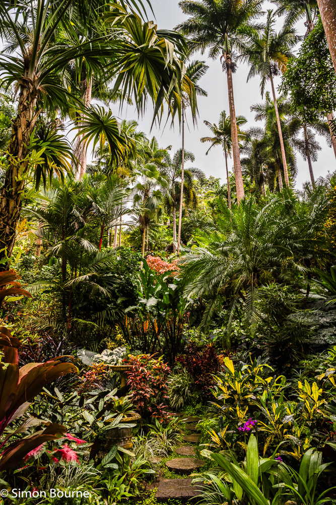
Hunte’s Garden is much smaller at just over 2 acres and is more cultivated. It has been created inside a limestone sink hole, ie a collapsed cave too. The area was originally a sugar cane plantation but has been transformed in to tropical gardens since 1990. Besides the flowers, especially the red Anthuriums, its main feature is the very tall array of palm trees, making it quite tricky to get their full height in to shots that also show the ground displays. This third image was taken at 24mm, f/11, 1/125s and ISO 200.
Feb 26 – Tropical Sunset over the Caribbean, Barbados
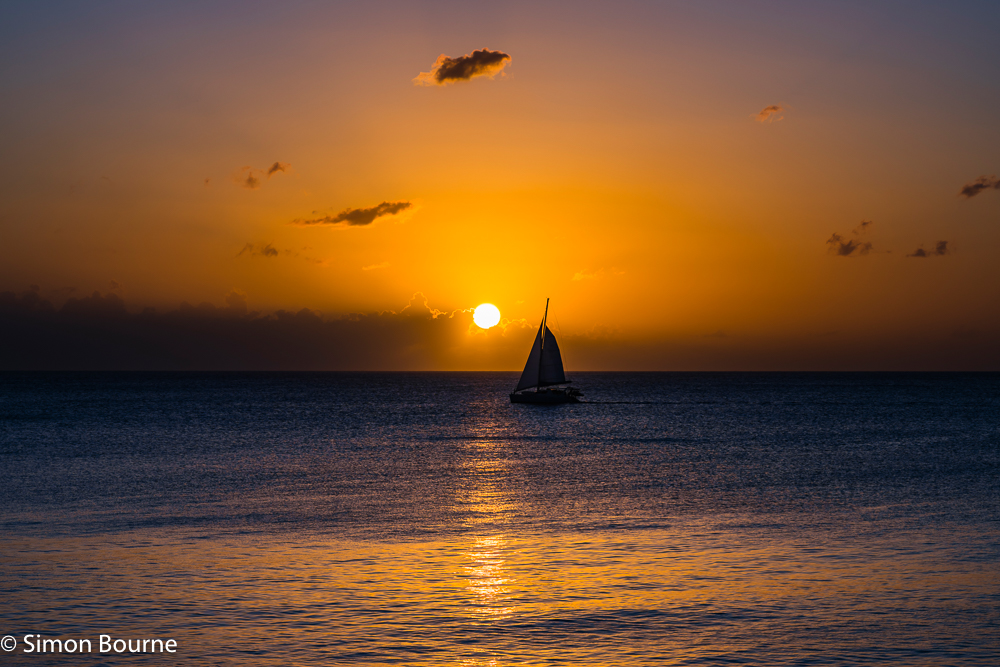
What’s not to love about a 30oC temperature during the day and still 25oC at night, and right in the middle of the “dry” season – best way to beat the cold, wet and windy weather in Cornwall at this time of year. These views are looking out over the Caribbean from the West Coast (the Leeward Side) of Barbados at Prospect Bay. It’s only 13 degrees North of the equator here, with the sun setting around 6pm on most days – it actually only ever varies between 5.30pm and 6.30pm over the whole year.
The first image was 6 minutes before the sunset, just before it dipped in to the thin layer of cloud over the sea. The reflections on the calm waters were still good and there were a number of yachts passing by to add some further interest. I used my full-frame mirrorless camera, the Nikon Z 7II, with the very versatile Z 24-120mm f/4 S lens, which is great for travel and landscape photography, using it at 80mm, f/11, 1/125s and ISO 64. The best WB was at 4,500K and I held the sky back by 0.4 stops to increase the drama.
Then, 4 minutes later, with the sunset just a couple of minutes away (it sets much quicker nearer the equator, of course), the sun had partially dropped behind the clouds. The reflections on the water were gone but replaced by the wonderful spread of the crepuscular rays in to the sky. It was immediately one stop darker and so I opened up the settings to f/9 and 1/100s while keeping the ISO at 64 – the focal length was also a little tighter at 95mm. Now, I found the better WB to be 5,000K, while I hardly held the darkening sky back at all, just by 0.1 stops.
More tropical delights to follow!
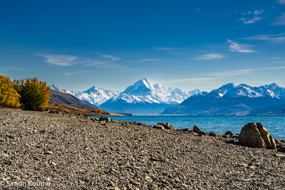
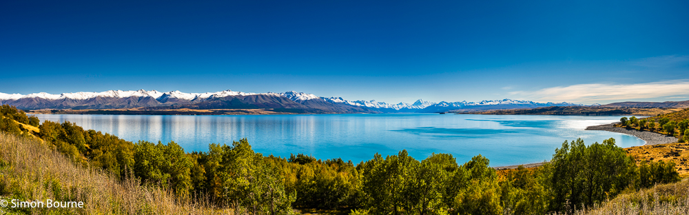
Feb 26 – The Majestic Lake Pukaki and Mount Cook, New Zealand
At last, with my hip now fully on the mend, I have got to the end of processing my New Zealand shots from last year! Next images soon to be posted will be from Barbados and St Vincent, from where we have just returned – proper tropical heat there to wave away any winter blues in February.
These last two photos were early morning as we left the Mount Cook National Park on our way back to Christchurch. The autumnal day was clear and crisp with fresh snowfall on the mountain peaks. Lake Pukaki picks up the melt waters from the Tasman, Hooker and Mueller Glaciers, as they join in to the Tasman River flowing in to the lake. The terminal moraine from the retreating glaciers blocked the valley allowing the lake to form. Its stunning green/turquoise to blue/aquamarine colours are the result of the glacial rock flour in the waters.
In the first image, by the shores of the lake, we could clearly see Mount Cook (3,724m) with the slightly lower Mount Tasman (3,497m) on its immediate right. It was the clearest long view that we had ever had of those peaks during both our trips to New Zealand. This was taken at 70mm on my Z 24-120mm f/4 S lens using f/14, 1/160s and ISO 64.
The final panorama was taken right at the southern tip of the lake near Twizel, looking back to Mount Cook again, 70km away. What a view and what colours! This composite was created in Photoshop from four merged Lightroom pictures, each taken at 28mm, f/13, 1/125s and ISO 64. The net result is a shot 14,100 by 4,400 pixels, ie 62MP – perfect for an exhibition-quality print around 180cm wide. Besides my usual Lightroom adjustments, both images used a WB of 7,000K and I held the sky back by 0.9 stops.
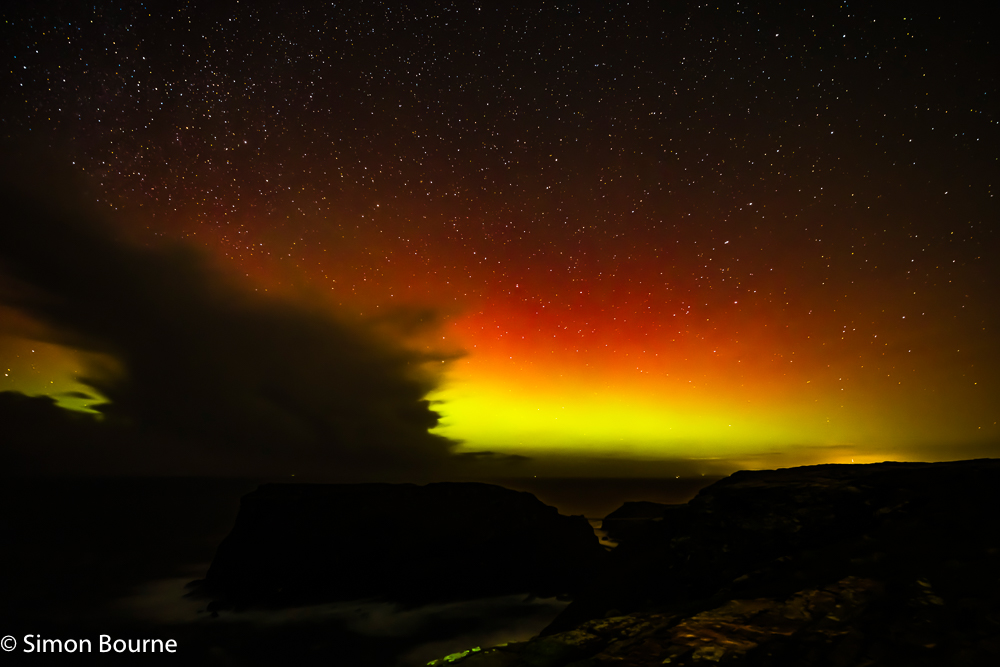
Jan 26 – Northern Lights over Tintagel Island, Cornwall
There were a number of occasions last year when solar flares produced northern lights (Aurora Borealis) even as far south as here in Cornwall, and yet every time, it was cloudy! Last night though, there was a reasonably good solar storm (a G3 category, following an X-class solar flare and coronal mass ejection (CME) on Monday), with geomagnetic field variations of about 800nT (nanoTesla) – typical field variations are less than 50nT. The sun is close to a solar maximum at the moment, which means a greater intensity of CMEs and solar storms, over an 11-year cycle.
The actual colours depend on whether the emitted plasma of electrons and protons hits the nitrogen or the oxygen in the sky, and at what altitude. Green is the most common in proper northern climes, as plasma hits oxygen atoms at 100-250km, but the colours here last night were definitely red, with a yellow-green glow beneath it.
Anyway, this shot was the best one, taken at about 9.30pm looking directly north across Tintagel Island from Glebe Cliff, just by St Materiana’s Church. It was mostly clear skies, though there was one block of dark cloud in the shot. You can see The Plough asterism (in the Ursa Major constellation) to the right, with its top leg pointing towards Polaris (the North Star), which is in the middle of the frame, right at the very top.
I used my Z 14-30mm f/4 S lens at 16mm with f/4, ISO 1600 and a 30s exposure – this is an EV of -5. With the naked eye, all you could see was a faint brightness, but the camera’s sensor clearly picks up way more light and colour. You then also have to use a fair amount of further adjustments in Lightroom to make the image really stand out!
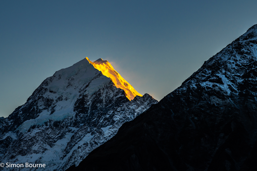
Jan 26 – The Wonderful Aoraki/Mount Cook, New Zealand
Last time we were in New Zealand in 2019, we didn’t really see Aoraki/Mount Cook at all, as it was bathed in the clouds nearly continuously. This time though, we saw it in all its 3,724m glory, mainly all on the same day!
This first wider shot was taken coming back from the Hooker Glacier in mid-afternoon, using 39mm, f/11, 1/125s and ISO 64. You can see the front peak and the higher rear peak is just about visible in the clouds. The second image is zoomed in at 73mm a few hours later at 5pm, as we passed the Mueller Glacier lake. The highest peak is now clearly visible. This was taken at f/9, 1/125s and ISO 100.
Finally, the best photo though was from our hotel at 7am the following morning, with a clear frosty start, no clouds and fantastic light on the snowy peaks. Over around 20 minutes, the light on the mountain tops went from red to orange to yellow. This image was the orange phase taken using 120mm, f/8, 1/100s and ISO 200. The natural WB was higher here at 8,000K and I only held the sky back by 0.5 stops. Then, besides my typical adjustments in Lightroom, I didn’t need to modify the colours much at all – it was exactly like that!
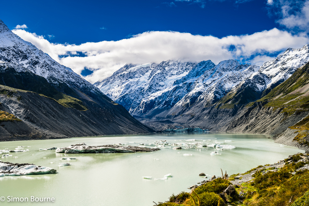
Jan 26 – Hooker Lake and Glacier, and Mount Cook, New Zealand
This was the trek that my hip went for first time – turned out it had become arthritic very quickly and after 2 hours walking, it was done for. Problem was the 2 hour hike back! So, I didn’t get as many shots around the Hooker Lake and Glacier that I had wanted, and Mount Cook was hidden in the clouds right up until we left. The Māori name for New Zealand is, of course, Aotearoa – “Land of the Long White Cloud”.
It was around midday when we got there and surprisingly busy with walkers – it took a while to remove them in Photoshop from my better images! Occasionally, I don’t mind the odd person to give some scale, but in general, I always remove people, as otherwise you start needing to get model releases for any images that you put on sale on Alamy. This shot is looking up the lake towards the 11km long Hooker Glacier, with its blue-green ice front covered in dark rock debris. Mount Cook/Aoraki is in the background with its peak at 3,724m just behind the top of those white clouds.
There were proper icebergs in the milky green waters of the terminal lake and the side moraine height shows how much the glacier has been retreating.
This shot was taken at 35mm on my Z 24-120mm f/4 S lens using f/13, 1/125s and ISO 64. The WB was best at 6,250K and I held the sky back by 0.9 stops. Fortunately, I got some better shots of Mount Cook a bit later – see my next blog!
Jan 26 – Mueller Lake and Glacier, New Zealand
On our walk up to the Hooker Lake and Glacier, where we got a great view of Aoraki/Mount Cook, we passed the beautiful Mueller Lake and Glacier. The 13km long Mueller Glacier is tucked up at the top of the lake and, like the lower sections of the Tasman Glacier, is covered in dark rock debris.
It was a stormy sort of day again, but with great shafts of sunlight poking their way through the dark skies – all very dramatic. The first autumn snows on the peaks added wonderfully to the whole scene.
The first shot was taken on my Z 24-120mm f/4 S lens at 24mm, f/10, 1/125s and ISO 80, with the glacier up on the far left corner of the milky green lake. The lake then forms the start of the Hooker River, which is flowing out on the bottom right corner of the image – this feeds in to the Tasman River, and on to Lake Pukaki.
The second photo is a panorama of five images across the lake, with the bluer aquamarine waters of Lake Pukaki on the far left, our hotel in the Mount Cook village also on the left, and the bottom of the Mueller Glacier on the far right. This merged photograph used a 24mm focal length, f/10, 1/125s and ISO 125. In addition to my usual Lightroom adjustments, I used a WB around here of 6,500K and held the sky back by one-stop to heighten the moody clouds.
On the full-size images, you can see the fine details of the blue ice on the mountain slopes above the glacier – not quite as visible on these much smaller resolution files used on my website!
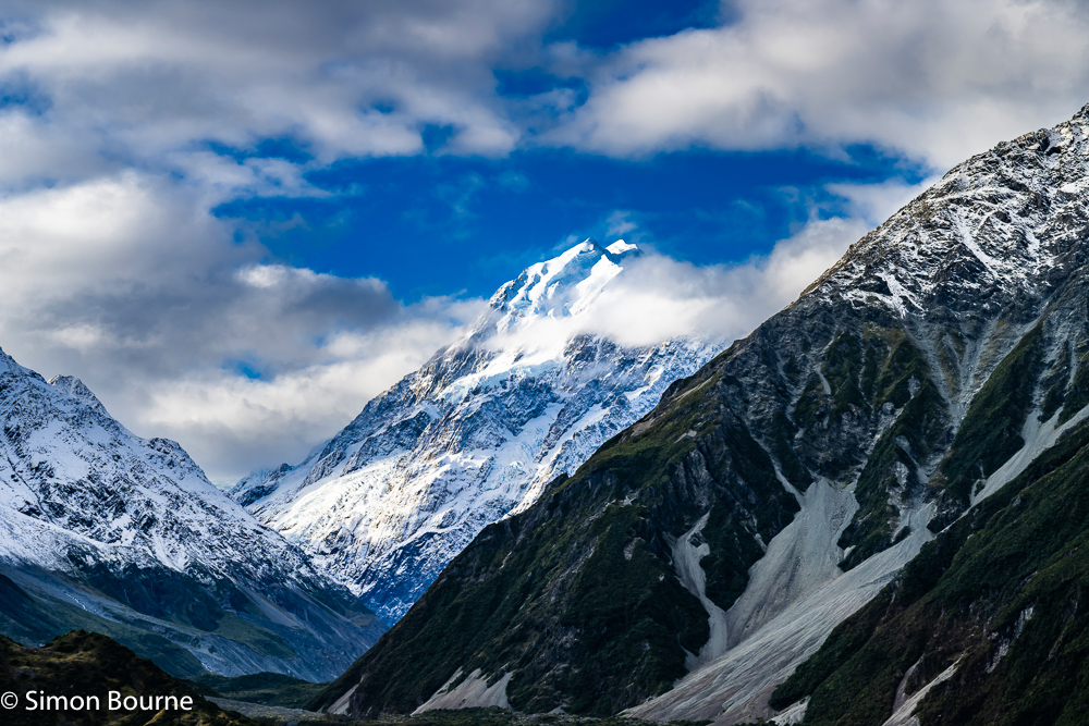
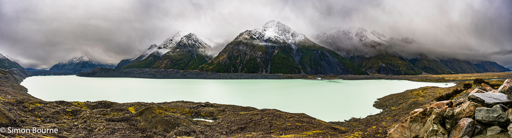
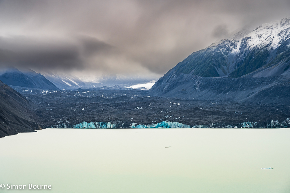
Jan 26 – Tasman Lake and Glacier, New Zealand
It stayed pretty wet and overcast all day, making the view over the Tasman Lake rather dull, but spectacular nevertheless. The Tasman Glacier to the left of the lake is the longest in New Zealand at around 24km. You can see the white icy top of the glacier further up the valley, while lower down by the lake, it is covered in dark rock debris.
This whole area is in the Mount Cook (Aoraki) National Park – Mount Cook itself (NZ’s highest peak at 3,724m) is behind the clouds to the left of both images. Fortunately, I got better pictures of that snowy peak a day later. The glacier feeds in to the Tasman Lake, which then flows down the valley as the Tasman River, before flowing in to the wonderful Lake Pukaki. At the higher levels, the waters are filled with glacial rock flour, which gives this very milky appearance. Lower down the valley as the flour settles, the waters become the greener turquoise or the bluer aquamarine, which is exactly what makes Lake Pukaki so spectacular.
This first image is a panorama of five shots taken on my Z 24-120mm f/4 S lens at 24mm, f/9, 1/100s and ISO 100, giving a final picture that is 18,100 by 4,900 pixels, ie 89MP. The first snows of autumn had happened overnight, which significantly improved the image, although much was lost in the low cloud. I was expecting the glacier to have retreated a lot since our last visit in 2019, but in comparing my photos, I couldn’t really see any huge difference. I believe the ice front has been quite stable for a few years now, whereas it was retreating by around 600m per year back in 2015.
The second photo is zoomed in to the glacier front using 120mm, f/10, 1/100s and ISO 100. The blue ice is now very apparent on the glacier wall, as are a small number of icebergs in the milky waters of the terminal lake.
Both pictures used a WB of 6,500K, together my usual range of adjustments in Lightroom, particularly to enhance the colours a tad more, and to dehaze the low cloud areas.
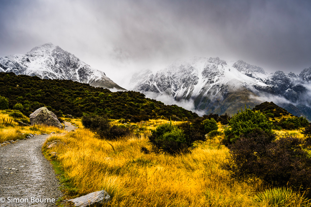
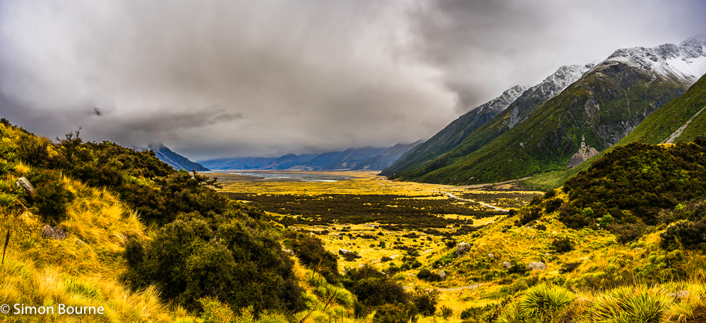
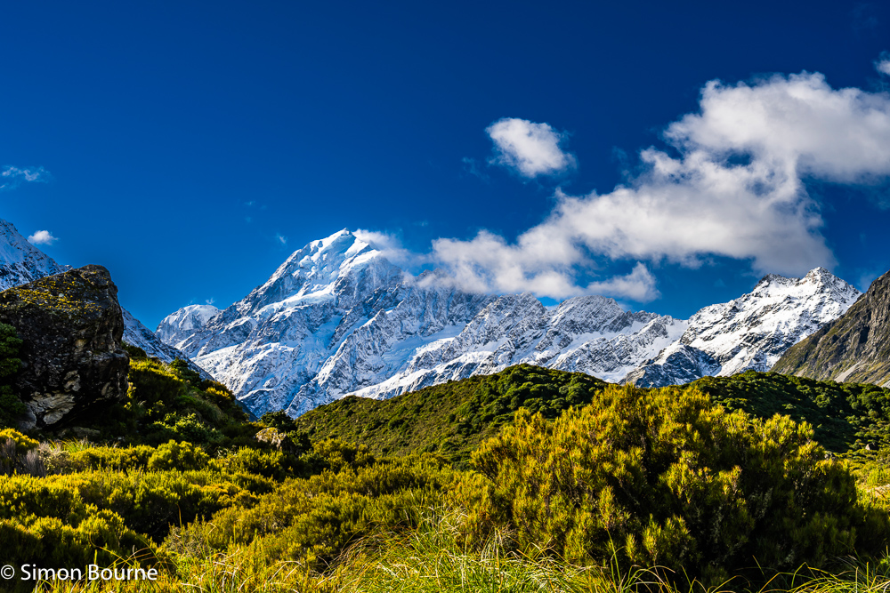
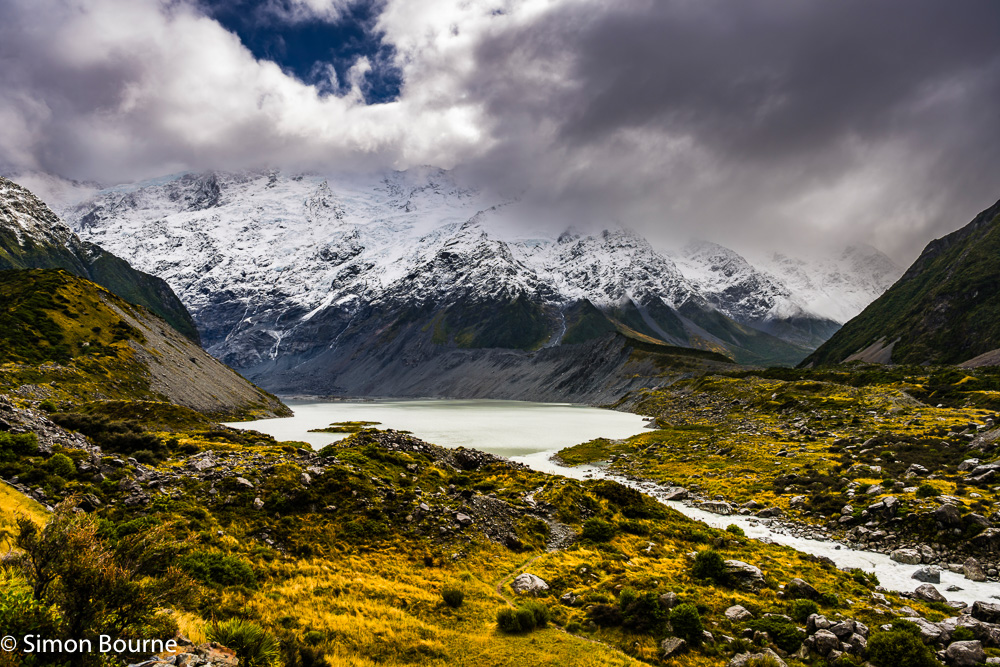
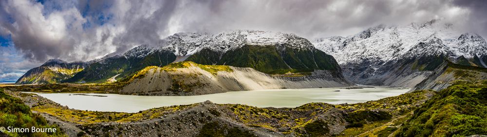
Jan 26 – First Autumn Snow, Tasman River Valley, New Zealand
I have done very little photography since we were in New Zealand last spring, as my hip had gone arthritic very quickly and it took a good few months to get a hip replacement, which then took quite a few months longer to recover. The net result being that for the last 6-9 months, I couldn’t either walk far or sit at my desk for long to do any post-processing. Anyway, I’m just now finishing off the images around the mountains and glaciers of Mount Cook.
These two photos were taken in the Mount Cook area, as we walked up to the Tasman Glacier and Lake. It was very wet and stormy, and the first snow fall of the autumn had occurred overnight on the higher peaks around the Tasman valley. Both were taken on my full-frame mirrorless camera, the Nikon Z 7II, using the very versatile Z 24-120mm f/4 S lens, which is great for travel and landscape photography.
The first photo was at about 10am looking up towards the snowy mountain peaks at 35mm, using f/9, 1/125s and ISO 125. Surprisingly, even though it was very cloudy and overcast, the light was unusually bright at around EV 13, which is only two stops down from a sunny day. I love the contrast between the moody sky, the snowy mountains and the bright yellow autumnal grasses.
The second shot is a panorama looking back down the glaciated Tasman River and valley. This was formed from two 24mm images merged in Photoshop, and both taken using f/9, 1/100s and ISO 125. The beauty of this next generation of mirrorless lenses is that they maintain their sharpness throughout their zoom ranges, which was not always true of the F-mount DSLR lenses.